Written by Jonny Bird
It seems appropriate to kick off this particular post with a reader disclaimer: having spent his entire life living in Northumberland, it is very possible that everything written by Jonny in this blog could well be biased… but we’ll let you be the judge of that!
The mighty Cheviot, the crown and jewel of Northumberland National Park, the highest point in the county and the only true gateway into Scotland. Now this view point might be hard to find if you ask any unassuming hillwalker out on their travels – the truth is the Cheviot, standing at 815m above sea level, has a bit of a bad reputation.
In fact, asking most weary traveller returning from the border country, you are more likely to hear stories of knee deep bog, drizzle and scathing winds sweeping across desolate moorland. Not exactly a recipe for a family day out!
However, having spent years camping, climbing and gazing across at this supposedly unpopular fell, I have come to cherish its wilderness, ruggedness and found a real joy hidden on its slopes.
The Cheviot Hills are a small, lesser known range that rise at the eastern end of the Southern Uplands. Straddling the border between England and Scotland, the rounded peaks centralise on an imposing flat-topped central point: The Cheviot. This area was formed like many of the UK’s mountains by volcanic action a very (very) long time ago followed by glacial sculpting. Although, unlike the more jagged peaks of the Western Lake District or the Scottish Highlands the Cheviots experienced a wide glacial covering in the last ice age, leaving a more flattened profile. While a visiting hiker expecting soaring ridges, and exposed scrambles might well be disappointed – these hills are by no means lesser for it.
Having parked in one of the many, well kept, free (yes free) car parks, laced up your boots and set out on a ramble – you will be struck by the wilderness of this place. It is quite common to spend a day in these hills without passing another soul – something that has become quite a rarity in many of our popular national parks. There is something atmospheric about being in such a rugged environment, feeling the wind, listening to nature talk amongst itself undisturbed. It can make us feel part of a landscape.
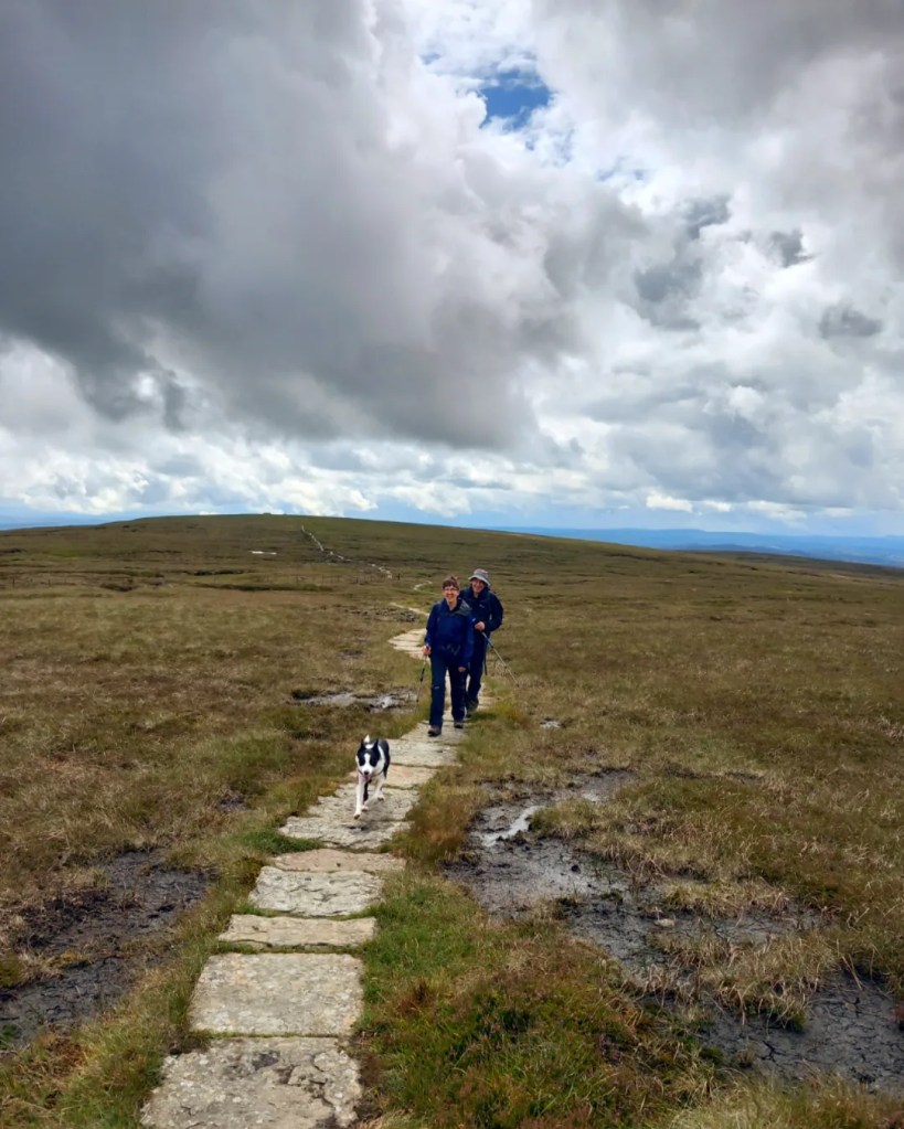
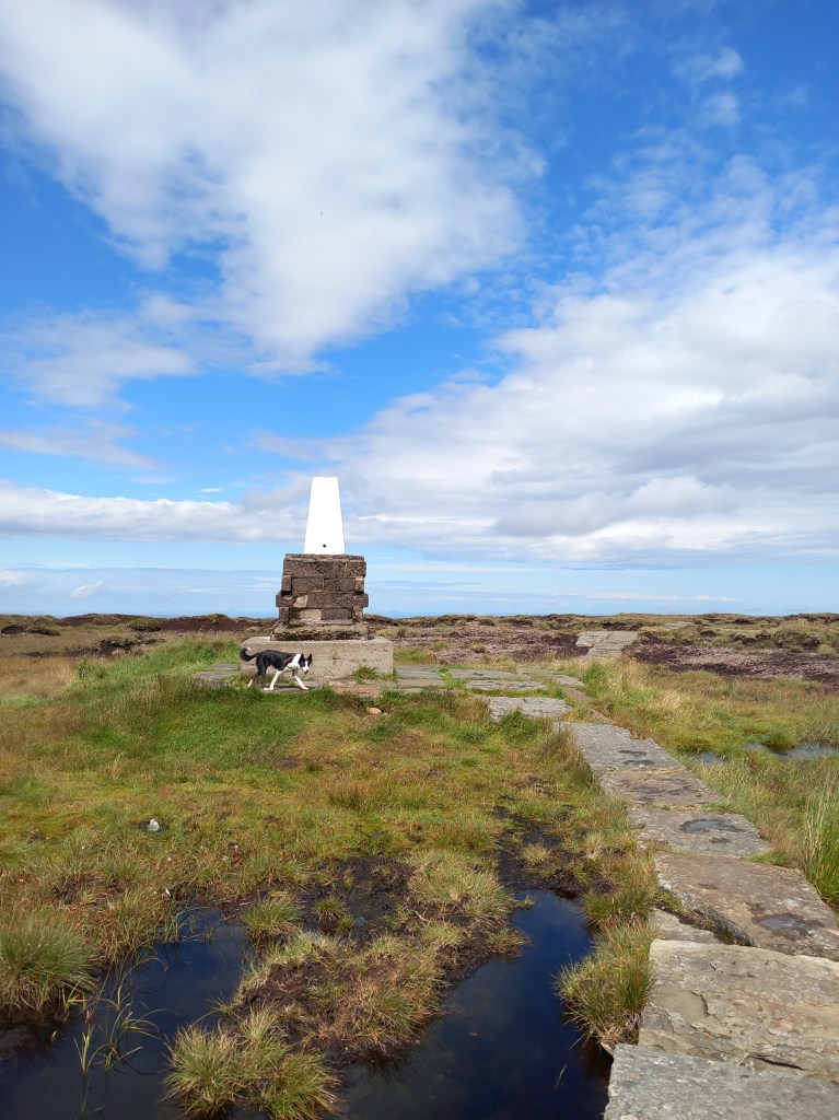
This experience is magnified when striding across the summit plateau of The Cheviot, looking across to the famous Northumberland coast to the East. The islands of Lindisfarne, the Farnes and Coquet nestled between the imposing sights of Bamburgh and Dustanburgh castles. To the West the Pennine way stretches over the border ridge and the Southern Uplands raise up in the distance. The well made flagstone path, and wire fence the only reminder of human activity in what seems like an ancient place.
This path is indeed a welcome aid in traversing the large area of peat bog that covers the summit; this bog forms part of the Border Mires – a well established area stretching over towards the Kielder forest, renowned for environmental significance in carbon-capture, bio-diversity and flood prevention. Indeed for half the year, it would be advised to stay strictly to this path to avoid spending an hour or two sinking knee deep into this environmentally significant gloop!
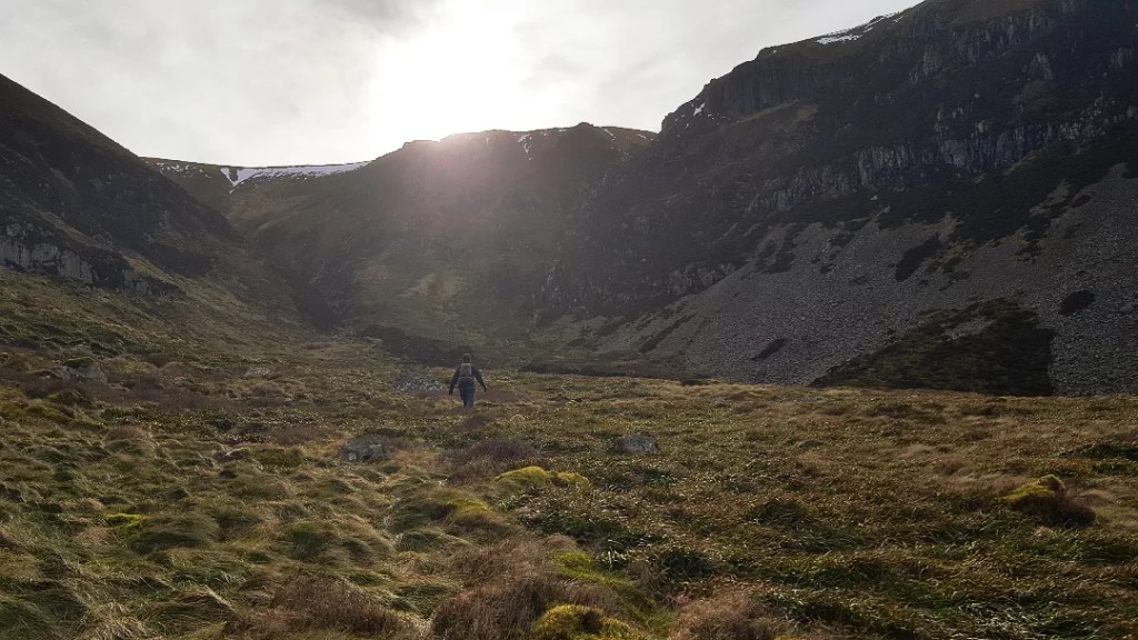
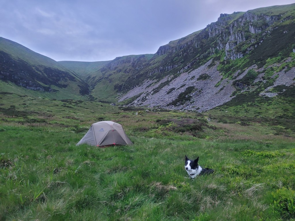
In the summer months however, some of the Cheviots more interesting routes open up, and provide a different access route for the distinctive summit marker: namely the Bizzle and Henhole valleys dug into its northern slopes. These dramatic gorges boast quite a different scene to the more gentle surrounding hills – with granite crags, waterfalls and deep glaciated valleys. These crags once held stories of exploration and discovery by local Northumbrian climbers, creating their own slice of history by climbing new routes on Cheviot granite. Gradually, over time these twin valleys have become more synonymous with remote wild camping than rock climbing – and for good reason. For those comfortable leaving the well trodden path behind, these places offer some of the most secluded camping spots in England.
While it must be conceded, the Cheviot may not be everyone’s cup of tea – and is unlikely to provide competition for ‘instagramability’ to the likes of Helvellyn’s striding edge or the rising towers of The Cobbler – something unique can certainly be discovered here. For on the slopes and valleys of this rounded giant, a real true wilderness can be appreciated, savoured and enjoyed.
Wild Mile Adventure offers guided walks in the Cheviot Hills as well as wild camping experiences and navigation courses. Want to explore this area under the guidance of a passionate local leader? Visit our website for more info here.
Recommended Routes
All year round
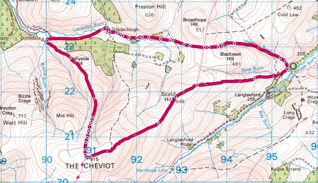
Our recommendation for an all season, circular walk.
Start: Langleeford
Finish: Langleeford
Distance: 13.8km
Time: 5 hours
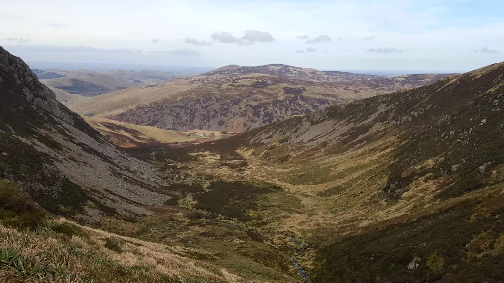
Description: A varied walk journeying through the farmed Harthope valley, before progressing up into rugged terrain and joining the Pennine Way and the summit plateau. Descend via Scald Hill – watch out for the boggy patches here!

A summer variation
A variation for the drier months of the year.
Start: Langleeford
Finish: Langleeford
Distance: 14.3km
Time: 6-7 hours
Description: Venture around the northerly side of the Cheviot to catch a glimpse into the Bizzle valley. Progress up Bellyside ridge (great name!), before the path disappears. Journey on to the summit tri point – good navigation skills and ability to use a compass are recommended for this section. Descend via Scald Hill.
A two day adventure
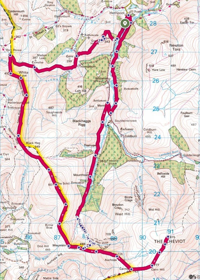
A two day adventure including a wild camp at the awesome Henhole valley.
Start: Hethpool
Finish: Hethpool
Distance: 33km
Time: 2 days
Description: Journey through the college valley from Hethpool towards the Henhole. Beyond Mounthooly there are some great places to pitch up and explore the valley above. The following morning an early start can allow time for a summit of the Cheviot before returning via the Pennine way to Hethpool.
Logistics and Planning
It is important to note that when venturing into these hills it is important to check the weather in advance, inform a friend of your plans for the day, be confident with navigation and to take the right equipment.
For any advice on accessing this amazing area, please contact us and we’d be happy to help.
Recommended Links
Harvey map of the Cheviots – https://www.harveymaps.co.uk/acatalog/Cheviot-Hills-YHSWCH.html
OS map of the Cheviots – https://shop.ordnancesurvey.co.uk/map-of-the-cheviot-hills/
Guiding from Wild Mile Adventure – https://wildmileadventure.co.uk/
wild.mile@outlook.com

Leave a comment